EN
EN
 AR
AR
 BG
BG
 FR
FR
 DE
DE
 HI
HI
 IT
IT
 JA
JA
 KO
KO
 PL
PL
 PT
PT
 RU
RU
 ES
ES
 SV
SV
 TL
TL
 ID
ID
 LV
LV
 LT
LT
 SR
SR
 UK
UK
 VI
VI
 TH
TH
 TR
TR
 FA
FA
 AF
AF
 HY
HY
 AZ
AZ
 KA
KA
 BN
BN
 LA
LA
 MN
MN
 SO
SO
 MY
MY
 KK
KK
 UZ
UZ
 KU
KU
 KY
KY
- সারসংক্ষেপ
- সংশ্লিষ্ট পণ্য
প্ল্যাটফর্ম পরিচিতি
ড্রোন সনাক্তকরণ সিস্টেমের মূল অংশ হিসেবে, লো-অলটিটিউড সিকিউরিটি কমান্ড অ্যান্ড কন্ট্রোল প্ল্যাটফর্ম S3-LAS-C5ISR ফ্রন্ট-এন্ড এবং ব্যাক-এন্ড পৃথক স্থাপত্য এবং মডুলার ডিজাইন ধারণা গ্রহণ করে। এটি GIS ভৌগোলিক তথ্য ইঞ্জিন, স্ট্রিমিং ডেটা প্রসেসিং ফ্রেমওয়ার্ক এবং বহু-উৎস তথ্য ফিউশন প্রযুক্তি একীভূত করে সিস্টেমের বিভিন্ন ডিভাইসগুলির একীভূত সমন্বয় এবং কেন্দ্রীভূত নিয়ন্ত্রণ বাস্তবায়ন করে। প্ল্যাটফর্মটি রাডার, ফটোইলেকট্রিক এবং রেডিও স্পেকট্রাম সহ বিভিন্ন ধরনের ডিভাইস অ্যাক্সেস করার ক্ষমতা রাখে, তাদের অপারেটিং স্থিতি পর্যবেক্ষণ করে, তাদের স্টার্ট এবং স্টপ নিয়ন্ত্রণ করে এবং কাজ সম্পাদনের জন্য স্কিডিউল করে। এটি কাজের প্রয়োজনীয়তা অনুযায়ী প্রতিটি সাবসিস্টেমের কাজের পরামিতিগুলি নমনীয়ভাবে কনফিগার করতে পারে এবং ডিভাইসগুলির কাজের স্থিতি গতিশীলভাবে পরিচালনা করতে পারে।
প্ল্যাটফর্মটি বহু-উৎস সনাক্তকরণ তথ্যের সমস্ত গুরুত্বপূর্ণ উপাদান যেমন লক্ষ্যবস্তুর গতির বৈশিষ্ট্য, তড়িৎ চৌম্বকীয় বর্ণালীর বৈশিষ্ট্য এবং রাডার, ফটোইলেকট্রিক ও বর্ণালী সংক্রান্ত সরঞ্জাম থেকে প্রাপ্ত চিত্র সনাক্তকরণের বৈশিষ্ট্যগুলি সম্পূর্ণরূপে একীভূত করে এবং ইউওএম প্ল্যাটফর্ম, এটিএম সিস্টেম ও পুলিশের মতো বাহ্যিক সিস্টেমগুলি থেকে তথ্য সমন্বয়ে প্রবেশাধিকার দেয়। এটি সতর্কীকরণ অঞ্চলের একটি একীভূত, নির্ভুল এবং সমসাময়িক বায়ু পরিস্থিতির মানচিত্র গঠন করে। সিস্টেমটি আগন্তুক উড়ন্ত বস্তুগুলি স্বয়ংক্রিয়ভাবে শনাক্ত করতে সক্ষম, কৃষ্ণ ও শ্বেত তালিকা কৌশলের সংমিশ্রণে লক্ষ্যবস্তুর পরিচয় পার্থক্য এবং হুমকি মাত্রা মূল্যায়ন করে এবং ড্রোন লক্ষ্যবস্তুগুলির পরিচয়, অবস্থান নির্ণয়, অনুসরণ, প্রমাণ অনুসন্ধান, শব্দ-আলোক সতর্কতা এবং সমন্বিত ব্যবস্থা পরিচালনাসহ সম্পূর্ণ প্রক্রিয়ার বদ্ধ-লুপ ব্যবস্থাপনা বাস্তবায়ন করে।
প্ল্যাটফর্মের সম্পূর্ণ পরিস্থিতি প্রদর্শন এবং সহায়ক সিদ্ধান্ত গ্রহণের ক্ষমতা রয়েছে, যা বায়ু পরিস্থিতি স্তর ওভারলে করা, লক্ষ্যবস্তু শ্রেণীবিভাগ প্রদর্শন, হুমকি স্তর ফ্ল্যাশিং অ্যালার্ম, এবং অঞ্চল লিঙ্কেজ নিয়ন্ত্রণের মতো কার্যক্রম সমর্থন করে, যা কার্যকরভাবে দায়িত্ব এবং নির্দেশনার দক্ষতা বাড়ায়। একই সাথে, প্ল্যাটফর্ম গোয়েন্দা নথিভুক্তিকরণ, ঐতিহাসিক পুনরায় পর্যালোচনা, তাপীয় পরিসংখ্যান এবং লগ অডিটের মতো কার্যকরী মডিউলগুলি একত্রিত করে, অনুভূতি থেকে গবেষণা এবং বিচার, এবং বিপত্তি থেকে প্রমাণ সংরক্ষণের পূর্ণ বদ্ধ লুপ অপারেশন প্রক্রিয়া নির্মাণ করে, বিমানবন্দরের নিম্ন-উচ্চতা নিরাপত্তা ব্যবস্থা নির্মাণ এবং পরিচালনাকে ব্যাপকভাবে সমর্থন করে।
প্ল্যাটফর্ম কার্যক্রম
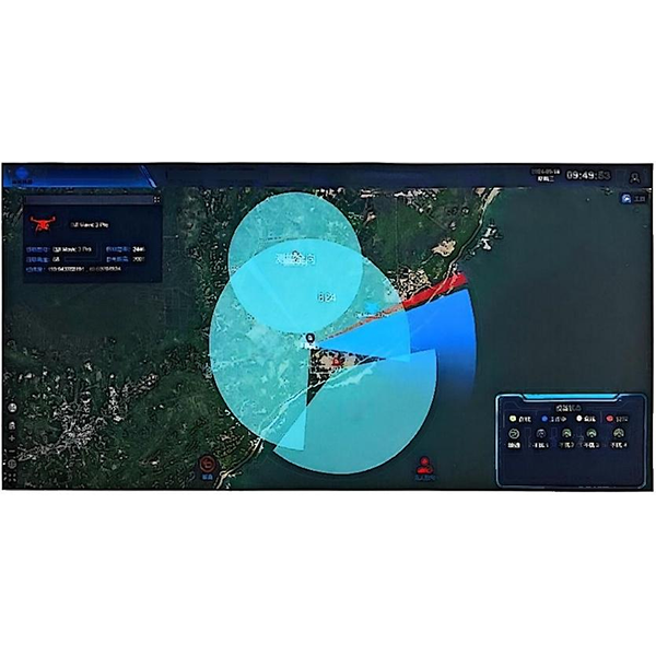
সম্পূর্ণ পরিস্থিতি নির্মাণ: প্ল্যাটফর্মটি একটি GIS ভৌগোলিক তথ্য ইঞ্জিন একীভূত করে, যা ভেক্টর মানচিত্র, স্যাটেলাইট মানচিত্র এবং তির্যক আলোকচিত্রসহ বহুস্তর সুইচিং সমর্থন করে এবং বিমানঘাঁটির রানওয়ে, রাডার আবরণ, প্রতিরক্ষা অঞ্চল বিভাগ এবং গুরুত্বপূর্ণ সুবিধাগুলির মতো তথ্য প্রদর্শন করে। এটি বিভিন্ন অঞ্চলের রং কোডযুক্ত সনাক্তকরণ সমর্থন করে এবং দূরত্ব পরিমাপ, ক্ষেত্র পরিমাপ, স্থানাঙ্ক নির্বাচন এবং সমোন্নতি পার্থক্য বিশ্লেষণের মতো অগ্রসর সার্ভে এবং ম্যাপিং ক্ষমতা সরবরাহ করে, রক্ষণ পরিস্থিতি মডেলিংয়ের জন্য একটি উচ্চ-নির্ভুলতা সম্পন্ন দৃশ্যমান ভিত্তি সরবরাহ করে। প্ল্যাটফর্মটি রক্ষিত অঞ্চলের তাপমান মানচিত্রগুলি স্বয়ংক্রিয়ভাবে তৈরি করতে সমর্থন করে এবং ড্রোনের ইতিহাস ভিত্তিক আক্রমণের ঘনত্ব অনুযায়ী উচ্চ ঝুঁকির অঞ্চলগুলি গতিশীলভাবে আপডেট করে।
বায়ু পরিস্থিতি প্রদর্শন: সিস্টেমটি রাডার, ফটোইলেকট্রিক, এটিএম, ইউওএম এবং রেডিও স্পেকট্রামের মতো বহু-উৎস ডেটাতে অ্যাক্সেসের সমর্থন করে এবং ফিউশন অ্যালগরিদমের মাধ্যমে সম্পূর্ণ উপস্থাপন করে। এটি সতর্কতা অঞ্চলে বায়ু অঞ্চলের সামগ্রিক নজরদারি বাস্তবায়নের জন্য একটি সম্পূর্ণ রিয়েল-টাইম বায়ু পরিস্থিতি মানচিত্র তৈরি করতে পারে। এটি লক্ষ্যবস্তুর হুমকি পর্যায়ের জন্য আইকন ফ্ল্যাশিং প্রম্পট এবং ট্র্যাক পুনরায় চালানোর কার্যক্রমের সমর্থন করে।
লক্ষ্যবস্তু তথ্য প্রদর্শন: প্ল্যাটফর্মটি লক্ষ্যবস্তুর বাস্তব-সময়ের স্থানাঙ্ক, উচ্চতা, গতিবেগ, ট্র্যাক, ফ্লাইট সময়, সনাক্তকরণ পদ্ধতি এবং সংকেতের ফ্রিকোয়েন্সি ব্যান্ডের মতো প্যারামিটার তথ্য প্রদর্শনের সমর্থন করে। এটি বিভিন্ন উৎস থেকে আগত লক্ষ্যবস্তুগুলির শ্রেণিবদ্ধ প্রদর্শনের সমর্থন করে, কালো এবং সাদা তালিকার লক্ষ্যবস্তুগুলি পৃথক করতে পারে এবং লক্ষ্যবস্তু সনাক্তকরণের চিত্র এবং আচরণ বিশ্লেষণের ফলাফল প্রদর্শন করতে পারে।
অনুপ্রবেশ রেকর্ড: প্ল্যাটফর্মটি স্বয়ংক্রিয়ভাবে সতর্কীকরণ অঞ্চলে প্রবেশকৃত অবৈধ ড্রোনগুলি শনাক্ত করতে পারে, চিহ্নিত করে এবং রেকর্ড করে। রেকর্ড করা বিষয়গুলির মধ্যে রয়েছে সময়, তারিখ, অবস্থান, ফ্লাইট পথ, ইত্যাদি এবং পরবর্তী ঘটনার পথ পুনরায় চালানোর সুবিধা রয়েছে। সমস্ত ডেটা ন্যূনতম 90 দিনের জন্য সংরক্ষিত থাকে এবং সর্বোচ্চ 5 বছর পর্যন্ত বাড়ানো যেতে পারে। এটি অনুপ্রবেশ ঘটনার স্বয়ংক্রিয় শ্রেণীবিভাগের কাজও রয়েছে।
তথ্য অনুসন্ধান: প্ল্যাটফর্মটি সময়, সরঞ্জাম, লক্ষ্য প্রকার, ফ্লাইট এলাকা এবং অন্যান্য শর্তের ভিত্তিতে বহুমাত্রিক সংযুক্ত অনুসন্ধান সমর্থন করে, চিত্র, ট্র্যাক এবং ঘটনার মতো ডেটার শ্রেণীবদ্ধ অনুসন্ধান সমর্থন করে এবং প্রয়োজন অনুযায়ী PDF, Excel, Word এবং অন্যান্য ফরম্যাটে রিপোর্ট তৈরি এবং রপ্তানি করতে পারে, যা তদারকি, ফাইল করা এবং গবেষণা ও বিচার সমর্থনে সহায়ক।
সম্পদ নিয়োজন ক্ষমতা: প্ল্যাটফর্মটিতে একটি অন্তর্নির্মিত কাজের সময়সূচি ইঞ্জিন রয়েছে, যা লক্ষ্যবস্তুর সংখ্যা, প্রতিরক্ষা অঞ্চলের মান এবং সরঞ্জামের অবস্থা অনুযায়ী গতিশীলভাবে সংসাধনগুলি যেমন রাডার, ফটোইলেকট্রিক এবং স্পেকট্রাম বরাদ্দ করতে পারে, সরঞ্জামের নিকটস্থ সহযোগিতা, কাজের অগ্রাধিকার বাছাই এবং লোড ব্যালেন্সিং সময়সূচি ব্যবস্থা বাস্তবায়ন করে, প্রতিক্রিয়া দক্ষতা বাড়ানোর জন্য।
তথ্য প্রেরণ: প্ল্যাটফর্মটি লক্ষ্য শনাক্তকরণের ফলাফল, বাতাসের পরিস্থিতির তথ্য, সতর্কতা বার্তা এবং অন্যান্য বিষয়বস্তু কর্মকর্তা, প্রতিনিয়ত কর্মী, নিরাপত্তা কর্মী এবং সংশ্লিষ্ট এককগুলিতে পাঠানোর সুবিধা প্রদান করে। এটি সংক্ষিপ্ত বার্তা এবং পপ-আপের মতো বিভিন্ন পদ্ধতিতে তথ্য সিঙ্ক করতে পারে যাতে প্রতিক্রিয়া সময় কমানো যায়।
একীভূত সরঞ্জাম পরিচালনার ক্ষমতা: প্ল্যাটফর্মটি একাধিক প্রোটোকল সহ একাধিক প্রস্তুতকারকের সরঞ্জামগুলিতে অ্যাক্সেসের সমর্থন করে এবং রিয়েল-টাইম অনলাইন স্ট্যাটাস মনিটরিং, ত্রুটি সনাক্তকরণ, রিমোট স্টার্ট এবং স্টপ, প্যারামিটার বিতরণ, স্বাস্থ্য মূল্যায়ন এবং লগ রিপোর্টিং এর মতো কার্যক্রম রয়েছে। এটি মানচিত্র পয়েন্ট প্রদর্শন, ব্যাচ অনলাইন এবং অফলাইন এবং গ্রুপ অপারেশন এবং রক্ষণাবেক্ষণ ব্যবস্থাপনার সমর্থন করে।
সম্পূর্ণ স্বয়ংক্রিয় কাজের ক্ষমতা: প্ল্যাটফর্মটি 7×24-ঘন্টা অবিচ্ছিন্ন অনুপস্থিতিতে অপারেশনের সমর্থন করে, যার মধ্যে রয়েছে স্বয়ংক্রিয় লক্ষ্য সনাক্তকরণ, স্বয়ংক্রিয় কৌশলগত প্রতিক্রিয়া, স্বয়ংক্রিয় ফলাফল লিঙ্কেজ, এবং স্বয়ংক্রিয় ঘটনা প্রতিবেদন সহ একটি কার্যকরী চেইন, যা সর্বকালীন অবিচ্ছিন্ন অপারেশনের ক্ষমতা নিশ্চিত করে।
সিস্টেম সার্ভার: প্ল্যাটফর্মটি সার্ভার এবং ওয়ার্কস্টেশন CPU, মেমরি এবং নেটওয়ার্ক ব্যবহারের রিয়েল-টাইম মনিটরিংয়ের সমর্থন করে। চূড়ান্ত অপারেশনের সময় সিস্টেম সংস্থান ব্যবহার 40% অতিক্রম করে না এবং এটি অপারেশন নিরাপত্তা এবং প্রতিক্রিয়া স্থিতিশীলতা নিশ্চিত করতে বহু-কাজ একযোগে প্রক্রিয়াকরণের সমর্থন করে।
সময় সিঙ্ক্রোনাইজেশন ফাংশন: প্ল্যাটফর্মটি ডেটা সংগ্রহ, ফিউশন, প্রদর্শন এবং রেকর্ডিং এর সামঞ্জস্য নিশ্চিত করার জন্য একটি সময়কালীন ব্যবস্থা দিয়ে সজ্জিত এবং এয়ারপোর্ট ঘড়ি সিস্টেমের সাথে সিস্টেমের সিঙ্ক্রোনাইজেশন নিশ্চিত করে।
তথ্য প্রেরণের ক্ষমতা: প্ল্যাটফর্মটি কমান্ডার, ডিউটি অফিসার এবং ডিসপোজাল ফোর্সের মতো কর্মকর্তাদের কাছে লক্ষ্য শনাক্তকরণের ফলাফল এবং সতর্কতা সম্পর্কিত তথ্য সম্প্রচারের সমর্থন করে এবং এসএমএস এবং পপ-আপের মতো বিভিন্ন বিজ্ঞপ্তি পদ্ধতির সমর্থন করে। এতে লিঙ্কেজ নিয়ন্ত্রণ ফাংশন রয়েছে, যা জরুরি লক্ষ্যের ক্ষেত্রে স্বয়ংক্রিয়ভাবে ভয়েস ব্রডকাস্ট ট্রিগার করতে পারে। একইসাথে, এটি প্রাপ্ত পুশ নিশ্চিত করার পর কার্যনির্বাহী কর্মীদের প্রতিক্রিয়া দেওয়ার সমর্থন করে, "পুশ-প্রাপ্তি-প্রতিক্রিয়া" এর একটি বদ্ধ-লুপ লিঙ্ক তৈরি করে।
অনুকরণ প্রশিক্ষণ ফাংশন: প্ল্যাটফর্মটিতে অনুকরণ করা লক্ষ্য ঢোকানো এবং প্রশিক্ষণ অনুশীলনের কাজ রয়েছে, যা প্রতিরোধ প্রক্রিয়া প্রশিক্ষণ, কৌশলগত নিয়মাবলী এবং প্রতিক্রিয়া পদ্ধতি পরীক্ষা করার জন্য ব্যবহার করা যেতে পারে, এবং সিস্টেমের প্রতিক্রিয়া ক্ষমতা যাচাই করার জন্য লক্ষ্য পরামিতি ম্যানুয়ালি সেট করার সমর্থন করে।
প্ল্যাটফর্ম প্রসারিত করার ক্ষমতা: প্ল্যাটফর্মটি খোলা ইন্টারফেস ক্ষমতা রাখে এবং তৃতীয় পক্ষের প্ল্যাটফর্মগুলির (যেমন পুলিশ, সামরিক, বেসামরিক বিমান পরিবহন UOM এবং বিমান যান নিয়ন্ত্রণ ATM) সাথে ডেটা অ্যাক্সেস এবং দ্বিমুখী যোগাযোগ সমর্থন করে একীভূত ব্যবস্থাপনা, তথ্য ভাগ করে নেওয়া এবং সহযোগিতামূলক প্রতিরোধ নিশ্চিত করতে পারে। ইন্টারফেস প্রোটোকলগুলি স্ট্যান্ডার্ড HTTPS, TCP, WebSocket, MQTT, ইত্যাদি সমর্থন করে, এবং ডেটা ফরম্যাটগুলি XML, JSON, GB/T সিরিজ প্রোটোকলের সাথে সামঞ্জস্যপূর্ণ।
পরিসংখ্যান রিপোর্ট করার ক্ষমতা: প্ল্যাটফর্মটি ড্রোন আক্রমণের প্রবণতা বিশ্লেষণ করতে সক্ষম, মাসিক, ত্রৈমাসিক এবং বার্ষিক তাপীয় পরিসংখ্যান চার্ট তৈরি করতে পারে, গুরুত্বপূর্ণ হুমকির দিকনির্দেশ এবং সময় ঘনত্ব বিতরণ বিশ্লেষণ করতে পারে এবং রিপোর্ট এক ক্লিকে ডাউনলোড করার সমর্থন করে।
ভূমিকা বরাদ্দ ক্ষমতা: প্ল্যাটফর্মটি বহু-ভূমিকা এবং বহু-স্তরের অনুমতি পরিচালনার সমর্থন করে, ব্যবহারকারীর আচরণ লগ রেকর্ডিং এবং অনুমতি অনুমোদনের সুবিধা সহ, বিমানবন্দর পরিচালনার নিরাপত্তা এবং নিয়ন্ত্রণযোগ্য এবং পরিচালনাযোগ্য রক্ষণাবেক্ষণের প্রয়োজনীয়তা পূরণ করে